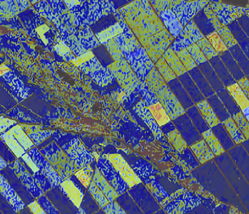
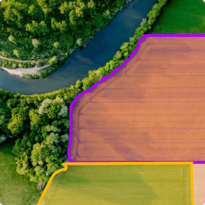
Optimize resources with geospatial AI.
In order to maximize land utilization, optimize crop yields, and promote sustainable practices, modern agriculture and resource management require innovative solutions.
However, traditional methods of data analysis and manual interpretation fail to fully harness the potential of available geospatial data, hindering effective decision-making for enhancing agricultural productivity, managing resources sustainably, and mitigating environmental risks.
Deep Block, a cutting-edge AI-powered geospatial analysis platform, is leading the way in addressing these challenges. By leveraging advanced computer vision technology, Deep Block empowers farmers and natural resources managers to focus on intricate analysis and strategic decision-making, while automating data processing and interpretation tasks with unparalleled precision and efficiency.
Unearthing Resource Intelligence.
The Deep Block Platform revolutionizes Agriculture and Natural Resources Management processes by harnessing the capabilities of AI and machine learning. Through Deep Block, individuals gain access to the wealth of geospatial data, facilitated by repeatable and automated processes that enable efficient analysis and insights. The platform's prowess lies in its ability to process high-resolution imagery with exceptional speed and scalability.
Satellite Imagery
Satellite imagery holds the potential to provide valuable insights into the understanding of landscapes, encompassing agricultural fields, forests, water bodies, and mineral resources. This data aids in assessing land use, vegetation health, and resource distribution, supporting informed decision-making in Agriculture and Natural Resources Management.
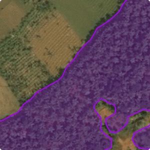
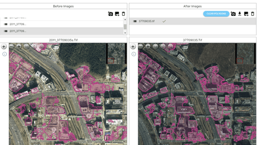
Aerial Photography
Aerial photography, captured from aircraft or helicopters, serves as a complementary resource to satellite data, furnishing consistent and reliable results while minimizing atmospheric interferences. It aids in precise field assessments, forest health evaluations, and monitoring of water bodies, fostering effective resource utilization and conservation.
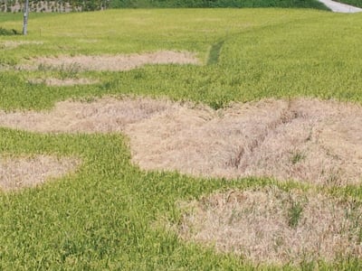
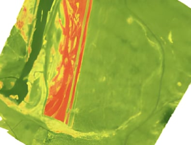
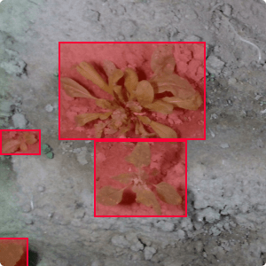
Drone Imagery
Drones facilitate targeted studies and reconnaissance missions. While drones cover smaller areas compared to traditional aircraft, their flexibility and precision make them adept at capturing imagery for specific regions of interest. From assessing soil moisture levels in agricultural fields to monitoring forest regeneration, drones provide valuable data for resource management strategies.
Unveiling Insights Across Farming and Natural Resources.
Deep Block's advanced computer vision algorithms are revolutionizing the domains of smart farming and natural resources management by harnessing the power of geospatial data. Our platform empowers agriculture experts and environmentalists to efficiently process and analyze large volumes of data, enabling them to make informed decisions and drive sustainable resource management.
Cattle Monitoring and Grazing Management
Monitor and analyze the condition of grazing lands, cattle, and livestock management systems. Detect and classify various cattle-related elements, identify overgrazed areas or potential health concerns, and provide valuable insights for optimizing cattle yield and resource allocation in livestock farming.
Mining Site Analysis
Analyze mining sites and mineral resource extraction areas using real-time data from various sources, including drone imagery and satellite data. This aids in efficient mine planning, assessing environmental impact, detecting land disturbances, and optimizing mineral extraction processes while minimizing ecological disruption.
Forestry Health Assessment
Assess the health of forests and vegetation cover over time. Detect and classify different types of trees, identify areas prone to deforestation or invasive species, and provide insights for sustainable forestry management, reforestation efforts, and biodiversity preservation.
Water Bodies Management
Monitor and manage water bodies such as lakes, rivers, and reservoirs. Detect changes in water levels, identify pollution sources, monitor aquatic vegetation, and provide insights for sustainable water resource management, ensuring clean and reliable water supply for communities and industries.
Harvest all your potential.
Deep Block supports a growing range of applications and lets you train your AI on multiple data sources.
Image Segmentation
Assign pixel-level labels to distinct regions within images, unlocking insights for geospatial data analysis. This capability aids in identifying crops, soil types, vegetation patterns, and changes over time. By diving into this granularity, agricultural experts can optimize resource allocation, monitor crop health, and enhance land management strategies.
Object Detection
Recognize and precisely locate objects within the context of the landscape. Detecting and delineating specific elements like crops, livestock, or equipment enables informed decision-making for optimal resource utilization, automated monitoring, and precise interventions.
Change Detection
Uncover and classify alterations in natural landscapes using bi-temporal or multi-temporal imagery. By comparing images taken over time, the platform identifies variations such as deforestation, land cover changes, or water body shifts. This insight aids in sustainable land use planning, forest management, and preserving ecological equilibrium.
Interested? Let's get in touch!
Whether it is to get a demo of our Deep Block Platform, inquire about our learning courses, join our latest Bootcamp or explore custom solutions with us, we will be happy to help!
The Deep Dive.
The Deep Dive is Deep Block's beloved Blog. It regroups all our successes and failures. It is an honest take on the challenges of a Computer Vision startup, an open opinion column for our experts, and the place to get our latest news.