
Why should you choose Deep Block? Learn about Deep Block's powerful and unique features.
First, read following articles.
The challenges of developing ML solutions for high resolution imagery
Pioneering Edge in Geospatial AI: Deep Block vs. ArcGIS.
-
Deep Block is equipped with an annotation tool.
Deep Block is software that allows you to develop and use computer vision models without coding. This software was initially designed for people unfamiliar with machine learning and computer science, and has been developed over five years to be able to handle even very high volumes of images.
The software provides training data preparation tools to help users train machine learning models.
Annotation tools exist for each application, and users do not need to use a third-party annotation tool, and there is no need to change the extension or divide the high-resolution GEOTIFF image or microscope images.
This is particularly beneficial for industries like defense, geospatial, and semiconductor manufacturing, where exporting data can be challenging.
This means, if necessary, the model's training data must be prepared in a place where the data exists and the network is blocked.
With Deep Block, users can develop machine learning models internally, even in isolated network environments, allowing for greater customization and control.
For example, the South Korean military wants to find North Korean tanks from the satellite photographs, but they cannot give satellite photos to private companies.
In this situation, Deep Block is the best option given to them.
Master the labeling tool -
We made everything.
Frequently, individuals from various backgrounds, particularly those in non-software fields within large Korean companies, inquire whether our machine learning technology is built using Amazon or Google's APIs. They are unaware that software such as AWS Sagemaker is limited in its ability to process images larger than 50MB.
However, we take pride in developing our software from scratch, ensuring that it is capable of efficiently processing high-resolution images. Over the course of nearly six years, we have dedicated ourselves to acquiring expertise in this field. Consequently, we possess a deep understanding of our software's architecture, enabling us to confidently handle high-resolution images.
Moreover, our knowledge of machine learning allows us to customize Deep Block according to our customers' specific requirements.
Whether it necessitates installing our software or integrating it with other applications, we possess the necessary expertise to collaborate effectively with other software engineers.
Our team comprises computer science professionals who are adept at navigating the intricacies of this field. -
We have an API too!
We created everything, so why can’t we create an API?
Of course, we already provide an API.
Our Github, and our software are all available, and if you have any further questions, please contact us directly.
Deep Block API Tutorial -
Powerful Frontend
Deep Block's frontend is designed to deliver an exceptional user experience, especially when it comes to rendering and labeling ultra-high resolution images. These images, which can exceed 100K in size, require substantial computing power to process. But users cannot feel what is happening.
Behind the scenes, a vast cluster of computers collaborates seamlessly to ensure the smooth operation of Deep Block. This coordination enables users to take full advantage of the software's powerful capabilities and achieve remarkable results. -
Capable of processing geospatial data
Aerial and satellite photos are often captured in the GEOTIFF format, containing valuable metadata.
However, these images are also in a tiled-tiff format, which poses challenges in the standard processing methods.
Fortunately, Deep Block has continuously enhanced its services and technologies to effectively handle such data. As a result, Deep Block users can effortlessly extract objects identified by their machine learning models in the GEOJSON format, enabling seamless integration with geographic information system (GIS) applications.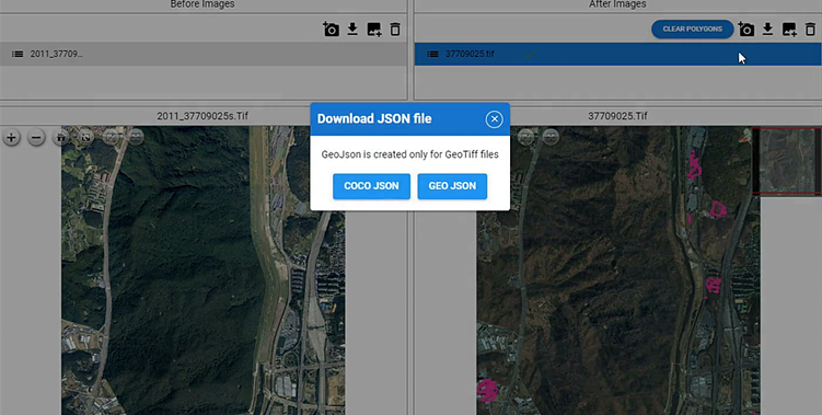
-
Optimization
We are working every day to fix bugs, improve speed, and resolve numerous issues that arise while processing extremely large size images.
We are still experiencing numerous problems, and this experience and the optimization we are doing are not easy to replicate. -
Differences between us and typical machine vision startups
Simply using open source machine learning models to analyze high-resolution images is not very helpful.
We've already written about this issue.
Furthermore, we take pride in being the only company that offers a machine vision platform for high-resolution imagery free of charge. We are dedicated to constantly improving our services based on user feedback and swiftly resolving any challenges that may arise.